


Featured
North and Middle Caicos, in a day.
The out-islands — lush, quiet, and worth the ferry ride.
The out-islands — lush, quiet, and worth the ferry ride.
Most visitors to Providenciales never leave it. The beach is long, the water is extraordinary, and the island is compact enough that there is always something else to do. But fifteen minutes off the eastern tip of Provo, across a stretch of shallow turquoise water, North Caicos sits waiting — greener, quieter, and almost entirely different in character.
North and Middle Caicos together make up the largest landmass in the archipelago. Their combined population is under 2,000. The roads are good. The beaches are empty. The caves in Middle Caicos are the largest dry cave system in the Bahamas-Turks and Caicos chain. Wade’s Green Plantation, in the North Caicos settlement of Kew, is the best-preserved Loyalist-era site in the country. Flamingo Pond is the only freshwater wetland in the archipelago.
One day is enough to understand why people who have spent time on both islands tend to consider the trip the most memorable thing they did on their visit.
Before you go
Ferry — Caribbean Cruisin’ operates the main passenger ferry from Heaving Down Rock at Provo’s eastern tip to Sandy Point Marina or Bellefield Landing, North Caicos. Check the schedule and book in advance; it fills up.
Car rental — essential and limited. Book before you travel. You can drive from North Caicos to Middle Caicos via the causeway — no second ferry needed.
National Trust sites — Wade’s Green Plantation and the Conch Bar Caves are managed by the Turks and Caicos National Trust. Check opening times and fees before you go.
Cash — bring it. Several sites charge entry fees and not all local restaurants take cards.
What to bring — sturdy shoes for the caves, swimwear, sunscreen, binoculars for Flamingo Pond, and more time than you think you need.
The history of the out-islands.
Lucayan middens, empty centuries, cotton plantations, and the families who stayed.
The people who first lived on North Caicos were Lucayan — the same Arawak-speaking people who settled the wider archipelago before European contact. Their evidence is in the middens, the shell piles and settlement traces that archaeologists have found across the island. They were removed by Spanish raiders in the early 1500s, taken to work elsewhere in the Caribbean, and the islands were left largely uninhabited for more than two centuries.
When settlement returned, it came with the American Revolution. British Loyalists who had backed the losing side were granted land across the Caicos Islands by the Crown, arriving with enslaved men and women to clear the bush and plant Sea Island cotton. North Caicos became the centre of that industry — the settlement of Kew its hub, and Wade’s Green its showpiece.
Wade Stubbs arrived in 1789 with a Crown land grant and built the largest plantation operation in the territory. By the time of his death in 1822, he held more than 8,000 acres across the Caicos chain and 384 enslaved people. The people who worked that land — who cleared it, planted it, and maintained it — had no choice in any of it, and no share in what it produced.
The cotton economy collapsed within a generation: boll weevil infestations, depleted soil, and hurricane damage made it unworkable, and most planters abandoned their holdings and returned to Britain. The enslaved population was not offered the same exit. They remained, on land they had worked but did not own, until emancipation came across the British Empire in 1833. The freed men and women built lives on North Caicos on their own terms. Their descendants form the backbone of the island’s population today, and family names — Stubbs, Forbes — run through the community in a way that carries the whole history inside it.
What is left of the plantation era is still standing on North Caicos in a way it is not elsewhere in the islands. Wade’s Green is the clearest record of it: the stone walls, the great house ruins, the wells, and the field boundaries, preserved by the same remoteness that has kept the island quiet ever since.

North Caicos.
Wade’s Green Plantation.
The stone ruins of the largest cotton plantation in the territory — and the most direct encounter with the history of these islands.
Wade’s Green sits just outside the settlement of Kew, a short drive from Bellefield Landing and the natural first stop on any day trip. The site is maintained by the Turks and Caicos National Trust: unpaved paths lead through the bush to the ruins of the great house, outbuildings, well shafts, and field walls. No visitor centre, no dramatisation. Just the ruins, the plaques, and the trees growing through the walls.
Cottage Pond.
A limestone blue hole, hidden in the bush.
A few minutes from Wade’s Green, just off Sandy Point Road, Cottage Pond is a circular blue hole sunk into the limestone — 255 feet deep, making it likely the deepest blue hole in the Turks and Caicos, its water a vivid blue against the surrounding green. It is a quick stop rather than a long one, but the scale of it — the depth, the clarity, the incongruity of it sitting in the middle of the bush — makes it worth the detour.
Three Marys Cays.
Three limestone cays, clear water, and the best snorkelling on the north shore.
Three Marys Cays is a protected sanctuary off the northeast coast of North Caicos — three small limestone cays surrounded by the clearest water on this side of the island. It is the right spot for a morning swim or snorkel before the day gets serious, and early enough in the day it tends to be entirely empty. From here, Pumpkin Bluff Pond is a short drive inland — a protected nature reserve where flamingos feed in the shallows alongside herons, egrets, and stilts.
Hollywood Beach lies on the approach, a long pale stretch of sand with the kind of colour that would be the main event anywhere else. Here it is the warm-up.
Eat: Miss B’s, Barracuda Beach Bar, and Big Josh’s Bar and Grill are the longstanding local spots for lunch on North Caicos. Authentic island food, unhurried, often excellent.
Flamingo Pond Overlook.
The only freshwater wetland in the archipelago.
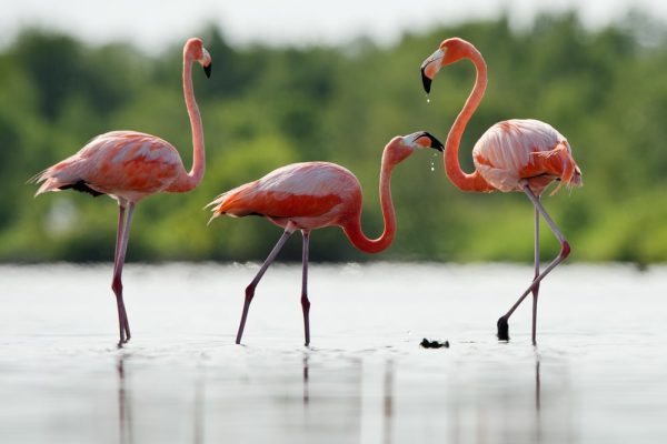
Between Whitby and Horsestable Beach on the north coast of North Caicos, a short pull-off gives views over Flamingo Pond — the largest freshwater wetland in the Turks and Caicos chain, and the one reliable place in the islands to see flamingos in any number. In the right season, the flock numbers in the thousands. Bring binoculars; the birds are further than they look from the road.
The causeway.
North Caicos to Middle Caicos, by road.
The Middle Caicos Causeway connects the two islands across Bottle Creek, one of the most productive fishing grounds in the archipelago, ringed by mangrove forest and teeming with birdlife. The drive across is short and the views are wide — the creek stretching out to the east, the mangroves dark against the bright sky. It is one of those drives that rewards slowing down.

Middle Caicos.
Mudjin Harbour.
Limestone cliffs, a rock formation, and the most dramatic beach in the chain.
Mudjin Harbour is the most photographed beach in the Turks and Caicos for good reason — limestone cliffs frame a wide bay of turquoise water with a beach below and Dragon Cay, a striking rock formation, rising from the surf at its eastern end. At low tide a sandbar emerges connecting the shore to the cay. The entrance to the beach is through The Amphitheatre, a large sea cave carved into the cliff face.
For the best view of the whole harbour, the Crossing Place Trail leads up from the beach to the cliff top — a short walk that repays the effort. The Circle of Hope monument, with its praying hands, stands at the top. The Mudjin Bar and Grill at Dragon Cay Resort is directly above the beach: the rum punch is cold and the view is the same from up there as it is from the sand.
Indian Cave and Conch Bar Caves.
The largest dry cave system in the Bahamas-Turks and Caicos chain.
Indian Cave lies on the main road heading east from Mudjin, free to enter, lit by natural skylights where the cave ceiling has collapsed. Barn owls nest here. Bats roost in the upper chambers. Giant blue land crabs move through the undergrowth at the base. Papaya and short-leaved fig grow in the open sections. It has the particular atmosphere of a place that exists entirely on its own terms.
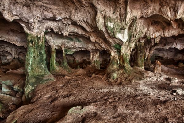
Further along the road, the Conch Bar Caves are in a different category — extensive, managed, and significant. Named for the nearby settlement, they form the largest dry cave system in the Bahamas-Turks and Caicos chain and contain archaeological material stretching back to pre-Columbian occupation. Entry is $20 USD and includes a guided tour of approximately one hour. Bring a light layer: the caves are cool, and the path requires steady footing.
Bambarra Beach.
The right place to end the day.
Bambarra Beach on Middle Caicos’s north coast is the quiet finish to the day — a long, calm, shallow beach shaded by casuarina pines, with a handful of vendors and the Bambarra Beach Bar nearby. The bar’s coconade — coconut water, lemonade, and gin, served in a fresh local coconut — is the specific recommendation. It is a good thing to drink at the end of a long day in the heat, on a beach with no one else on it, watching the light change over the water.